…FLOOD WATCH REMAINS IN EFFECT THROUGH FRIDAY MORNING…
The Flood Watch continues for
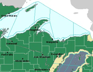
* Portions of central Upper Michigan and western Upper Michigan, bincluding the following areas, in central Upper Michigan, Alger, Baraga, Delta, Dickinson, Iron, Luce, Marquette, Menominee, Northern Schoolcraft, and Southern Schoolcraft. In western Upper Michigan, Gogebic, Keweenaw, Northern Houghton, Ontonagon, and Southern Houghton.
* Through Friday morning
* Temperatures staying above freezing combined with rainfall amounts of a half inch to an inch may lead to minor flooding through Friday. The flooding potential will begin to ease on Friday as temperatures fall back below freezing.
* Though the snowpack will absorb some of the rain, slowing the runoff into primary rivers, it is likely that the rainfall and
snowmelt will cause some rise in water levels on smaller streams and rivers over the next couple of days. Breakup ice jams may
also develop on some rivers and streams. In addition, there will be ponding of water in low-lying and poor drainage areas as well as possible basement flooding. The added weight of the rain soaked snow could also result in roof collapses.
A Flood Watch means there is a potential for at least minor flooding based on current forecasts. Additional impacts are likely due to the deep, water logged snow pack on the ground. You should monitor later forecasts and be alert for possible Flood Warnings. Those living in areas prone to flooding should be prepared to take action should flooding develop.