…WINTER STORM WATCH IN EFFECT FROM LATE WEDNESDAY NIGHT THROUGH LATE THURSDAY NIGHT…
* WHAT…Wet heavy snow and light freezing rain possible. Total snow accumulations of 5 to 10 inches and ice accumulations of up to one tenth of an inch possible. Winds could gust as high as 35 mph.
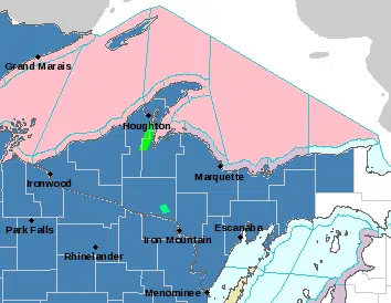
* WHERE…Portions of central Upper and western Upper Michigan.
* WHEN…From late Wednesday night through late Thursday night.
* ADDITIONAL DETAILS…Travel could be very difficult. Patchy blowing snow could significantly reduce visibility. The hazardous conditions could impact the morning and evening commute on Thursday. The combination of wet snow and gusty winds may lead to scattered power outages.
PRECAUTIONARY/PREPAREDNESS ACTIONS…A Winter Storm Watch means there is potential for significant snow, sleet or ice accumulations that may impact travel. Continue to monitor the latest forecasts.