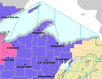
Including the cities of Menominee, Escanaba, and Gladstone

...WINTER WEATHER ADVISORY IN EFFECT FROM 7 PM EST /6 PM CST/
THIS EVENING TO 7 PM EST /6 PM CST/ MONDAY...

* WHAT...Mixed precipitation expected. Total snow accumulations
  of up to two inches and ice accumulations of a light glaze.

* WHERE...Menominee and Delta Counties.

* WHEN...From 7 PM EST /6 PM CST/ this evening to 7 PM EST /6 PM
  CST/ Monday.

* IMPACTS...Plan on slippery road conditions. The hazardous
  conditions could impact the morning or evening commute.

* ADDITIONAL DETAILS...Drizzle this evening will begin to freeze
  overnight as temperatures drop. Roads may be especially
  slippery for the Monday morning commute due to a light glaze
  on untreated roads. Monday morning, a mix of freezing drizzle
  and snow will become all snow around midday.
Including the cities of Grand Marais and Munising

...WINTER WEATHER ADVISORY IN EFFECT FROM 7 PM THIS EVENING TO
10 PM EST MONDAY...

* WHAT...Mixed precipitation expected. Total snow accumulations
  of 2 to 4 inches and ice accumulations of a light glaze up to
  perhaps a tenth of an inch. Winds gusting as high as 35 mph
  late Monday near Lake Superior.

* WHERE...Alger County.

* WHEN...From 7 PM this evening to 10 PM EST Monday.

* IMPACTS...Plan on slippery road conditions. The hazardous
  conditions could impact the morning or evening commute.

* ADDITIONAL DETAILS...Drizzle this evening will begin to freeze
  overnight as temperatures drop. Monday morning, a mix of
  freezing drizzle and snow will become all snow around midday.
Including the cities of Gwinn and Marquette

...WINTER WEATHER ADVISORY NOW IN EFFECT FROM 7 PM THIS EVENING
TO 10 PM EST MONDAY...

* WHAT...Mixed precipitation expected early Monday, then snow.
  Total snow accumulations of 3 to 7 inches and ice
  accumulations of a light glaze. Lower snowfall amounts are
  expected near and south of Gwinn.

* WHERE...Marquette County.

* WHEN...From 7 PM this evening to 10 PM EST Monday.

* IMPACTS...Travel could be very difficult. The hazardous
  conditions will impact the morning and evening commutes.

* ADDITIONAL DETAILS...Drizzle this evening will begin to freeze
  overnight as temperatures drop. Monday morning, a mix of
  freezing drizzle and snow will become all snow from north to south.
Including the cities of Iron River and Iron Mountain

...WINTER WEATHER ADVISORY NOW IN EFFECT FROM 6 PM THIS EVENING
TO 6 PM CST MONDAY...

* WHAT...Freezing drizzle expected tonight, then snow.
  Total snow accumulations of 2 to 4 inches and ice
  accumulations of a light glaze.

* WHERE...Iron and Dickinson Counties.

* WHEN...From 6 PM this evening to 6 PM CST Monday.

* IMPACTS...Plan on slippery road conditions. The hazardous
  conditions could impact the morning and evening commutes.

* ADDITIONAL DETAILS...Freezing drizzle will mix with and then
  transition to all snow by mid morning on Monday. Roads may be
  slippery for the Monday morning commute due to a light glaze on
  untreated roads.