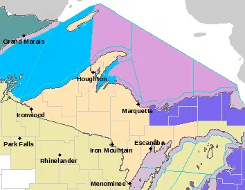
Including the cities of Grand Marais, Munising, Newberry,and Seney
WINTER WEATHER ADVISORY IN EFFECT FROM 1 PM THIS AFTERNOON TO 1 PM EST WEDNESDAY
Lake effect and blowing snow expected. Total snow accumulations of 4 to 7 inches. Locally higher amounts may be possible from near Chatham to Melstrand and eastward toward Pine Stump Junction. Travel could be very difficult. Patchy blowing snow could significantly reduce visibility. The hazardous conditions could impact the evening commute as well as the morning commute on Wednesday. Cold wind chills as low as 20 below zero could cause frostbite on exposed skin in as little as 30 minutes. Slow down and use caution while traveling. Be sure to dress warmly and do not leave pets outside for extended periods of time.
Including the cities of Paradise, Trout Lake, Rudyard,Sault Ste. Marie, Brimley, Kinross, and Sugar Island
…WINTER WEATHER ADVISORY REMAINS IN EFFECT UNTIL 7 PM EST WEDNESDAY…
* WHAT…Lake effect snow will develop later today and continue through Wednesday. Total snow accumulations of 3 to 7 inches. Winds gusting as high as 35 mph will result in areas of blowing snow. Travel could be very difficult. The hazardous conditions could impact the morning or evening commute. The cold wind chills as low as 20 below zero could cause frostbite on exposed skin in as little as 30 minutes. Wind chills of -5 to -15 degrees late tonight through much of Wednesday. Slow down and use caution while traveling.