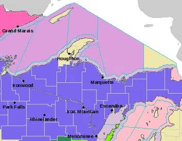
Including the cities of Grand Marais, Munising, Newberry,
Escanaba, Gladstone, Manistique, and Seney

...WINTER WEATHER ADVISORY REMAINS IN EFFECT FROM 7 PM THIS EVENING TO 10 AM EST SUNDAY...

* WHAT...Mixed precipitation expected. Total snow accumulations
  of up to two inches and ice accumulations of around one tenth
  of an inch. For communities along the Great Lakes, ice
  accumulations will remain less than one tenth of an inch.

* WHERE...Alger, Luce, Delta, Southern Schoolcraft and Northern
  Schoolcraft Counties.

* WHEN...From 7 PM this evening to 10 AM EST Sunday.

* IMPACTS...Plan on slippery road conditions.

* ADDITIONAL DETAILS...If temperatures end up being colder, ice
  accumulations may be more significant across the Seney Stretch
  and Luce County.
Including the cities of Ontonagon, Ironwood, Iron River,
Iron Mountain, Menominee, Kenton, and Sidnaw
350 PM EST Sat Dec 28 2019 /250 PM CST Sat Dec 28 2019/

...WINTER WEATHER ADVISORY REMAINS IN EFFECT UNTIL 10 AM EST/9 AM CST/ SUNDAY...

* WHAT...Mixed precipitation expected. Total snow accumulations
  of up to two inches along and west of a line from Crystal
  Falls to Nisula. Ice accumulations of one to two tenths of an
  inch, mainly along and north of the Wisconsin border between
  Watersmeet to Crystal Falls to La Branche. Little to no snow
  or ice accumulations are expected across southern Menominee
  County.

* WHERE...Portions of central Upper and western Upper Michigan.

* WHEN...From 4 PM EST /3 PM CST/ this afternoon to 10 AM EST /9
  AM CST/ Sunday.

* IMPACTS...Plan on slippery road conditions.

* ADDITIONAL DETAILS...If temperatures warm a degree or two more
  than currently forecast, ice accumulations may be less
  significant.
Including the cities of L`Anse, Gwinn, and Marquette
350 PM EST Sat Dec 28 2019

...WINTER WEATHER ADVISORY REMAINS IN EFFECT FROM 7 PM THIS EVENING TO 10 AM EST SUNDAY...

* WHAT...Mixed precipitation expected. Total snow accumulations of
  up to three inches, with lesser amounts for communities along
  Lake Superior. Ice accumulations of one to two tenths of an
  inch, along and south of US-41, and across the Michigamme
  Highlands. Higher ice amounts are possible over the rural areas
  of the Michigamme highlands north of US-41. No ice
  accumulations are expected for communities along the Lake
  Superior shoreline.

* WHERE...Baraga and Marquette Counties.

* WHEN...From 7 PM this evening to 10 AM EST Sunday.

* IMPACTS...Plan on slippery road conditions.

* ADDITIONAL DETAILS...If temperatures warm a degree or two more
  than currently forecast, ice accumulations may be less
  significant.