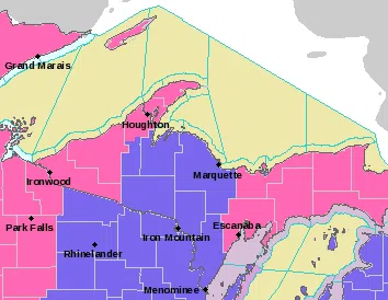
Including the cities of Escanaba, Gladstone, and Manistique
…WINTER STORM WARNING IN EFFECT UNTIL 10 PM EST THIS EVENING…
* WHAT…Heavy snow. Additional snow accumulations of 3 to 5 inches. Storm total snow accumulations of 8 to 12 inches.
* WHERE…Delta and Southern Schoolcraft Counties.
* WHEN…Until 10 PM EST this evening.
* IMPACTS…Travel could be very difficult at times. Visibilities could be sharply reduced with heavier snow bands.
* ADDITIONAL DETAILS…Heavy snow with snowfall rates of about one inch per hour will continue through mid-afternoon. The snow will then become lighter and continue into the evening. If you must travel, keep an extra flashlight, food, and water in your vehicle in case of an emergency.
Including the cities of Grand Marais, Munising, Newberry, and Seney
…WINTER STORM WARNING IN EFFECT UNTIL 1 PM EST SUNDAY…
* WHAT…Heavy snow. Additional snow accumulations of 5 to 8 inches. Storm total snow accumulations of 8 to 14 inches.
* WHERE…Alger, Luce and Northern Schoolcraft Counties.
* WHEN…Until 1 PM EST Sunday.
* IMPACTS…Travel could be very difficult. Visibilities could be sharply reduced with heavier snow bands today, and stronger lake- effect snow bands tonight.
* ADDITIONAL DETAILS…Heavy snow with snowfall rates of about one inch per hour will continue through mid-afternoon. The snow will then become lighter and continue into the evening.
Including the cities of L`Anse, Gwinn, Marquette, Iron River, Kenton, and Sidnaw
…WINTER WEATHER ADVISORY REMAINS IN EFFECT UNTIL 1 PM EST /NOON CST/ SUNDAY…
* WHAT…Snow. Additional snow accumulations of 2 to 6 inches, except 6 to 10 inches over the Michigamme Highlands. Storm total snow accumulations of 8 to 12 inches, except 12 to 16 inches over the Michigamme Highlands.
* WHERE…Portions of central Upper and western Upper Michigan.
* WHEN…Until 1 PM EST /noon CST/ Sunday.
* IMPACTS…Travel could be very difficult. Visibilities could be sharply reduced with heavier snow bands today, and stronger lake- effect snow bands tonight.
* ADDITIONAL DETAILS…Steady, occasionally heavy snow will continue through early afternoon. The snow will then transition into lake-effect snow showers this afternoon and continue into Sunday in the north wind snow belts near Lake Superior. These snow showers could be heavy at times.