The National Weather Service has extended many of the Winter Storm and Blizzard Warnings for another few hours as winds have not died down across the Upper Peninsula, and the snow continues to fall in areas of the Lake Superior snowbelt.
The Winter Storm Warning in Delta County was due to expire at 7 p.m. Saturday night, but has now been extended through 1 a.m. Christmas morning. Another 2-to-4 inches of snow is possible in the northern and eastern parts of the county, and in the Escanaba area, high winds continue to blow snow onto the city’s streets, sidewalks, and parking lots.
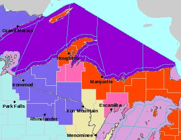
In Iron County, a Winter Weather Advisory is in effect until 7 a.m. Sunday, with another 1-to-3 inches of snow possible, along with the high winds.
In Alger, Luce, and northern Schoolcraft Counties, a Blizzard warning remains in effect until 7 a.m. Sunday, with another 3-to-9 inches of snow expected, blown around by 55 mile per hour wind gusts.
In Marquette and southern Schoolcraft Countties, including the cities of Marquette and Manistique, the Blizzard Warning is due to expire at 1 a.m. Sunday, with another 2-to-7 inches of snow and blowing snow. The Blizzard Warning in Houghton and Keweenaw Counties continue through 7 a.m. Sunday, with six more inches of snow and blowing snow.
In the far western U.P., a Winter Weather Advisory is in effect until 7 a.m. Sunday for Ontonagon and Gogebic Counties as the winds will start to subside. About 1-to-3 inches of snow could still fall.
The far eastern U.P., which is served by the National Weather Service office in Gaylord, has a Blizzard Warning until 7 a.m. on Sunday. In Chippewa and Mackinac Counties, another 4-to-8 inches of snow, along with 40 mile-per-hou winds, will cause more blowing and drifting of snow overnight.
All warnings and advisories have expired in Dickinson and Menominee Counties.
Here are the latest wind totals from the National Weather Service in Marquette for Saturday.
PRELIMINARY LOCAL STORM REPORT…SUMMARY NATIONAL WEATHER SERVICE MARQUETTE MI 422 PM EST SAT DEC 24 2022
0951 AM NON-TSTM WND GST COPPER HARBOR M71 MPH KEWEENAW MI ASOS KP59 COPPER HARBOR.
0640 PM NON-TSTM WND GST GRANITE ISLAND M69 MPH MARQUETTE MI MESONET MESONET STATION GRIM4, 11 N TROWBRIDGE PARK.
0624 AM NON-TSTM WND GST 34 ENE ROCK OF AGES M69 MPH KEWEENAW MI MESONET MESONET STATION OJIM4 OJIBWAY – ISLE ROYALE.
1100 AM NON-TSTM WND GST STANNARD ROCK LIGHTHOUS M67 MPH LSZ266 MI C-MAN STATION C-MAN STATION STDM4, 27 ESE KEWEENAW POINT.
0853 AM NON-TSTM WND GST HOUGHTON CO AIRPORT M66 MPH HOUGHTON MI ASOS STATION KCMX HOUGHTON CO. AIRPORT.
0600 AM NON-TSTM WND GST PASSAGE ISLAND LIGHTHOUSE M66 MPH LSZ264 MI C-MAN STATION C-MAN STATION PILM4, 53 NNW EAGLE HARBOR.
0656 AM NON-TSTM WND GST MUNISING M63 MPH ALGER MI ASOS STATION KP53 MUNISING.
1050 AM NON-TSTM WND GST GRAND MARAIS M61 MPH LSZ251 MI MESONET GLOS WEATHER STATION GRMM4, 1 NNE GRAND MARAIS.
1130 AM NON-TSTM WND GST FREDA M56 MPH HOUGHTON MI TRAINED SPOTTER REPORT PROVIDED ON FACEBOOK.
1254 PM NON-TSTM WND GST 1 NW KINGSFORD M55 MPH DICKINSON MI ASOS STATION KIMT KINGSFORD.
1220 PM NON-TSTM WND GST BIG BAY M54 MPH LSZ248 MI MESONET STATION BIGM4 BIG BAY.
1020 AM NON-TSTM WND GST FAIRPORT M52 MPH LMZ250 MI MESONET GLOS WEATHER STATION FPTM4, 6 S FAYETTE.
1150 AM NON-TSTM WND GST 5 S SANDS M44 MPH MARQUETTE MI AWOS STATION KSAW SAWYER AIRPORT.
0507 PM NON-TSTM WND GST 1 SSW ALLOUEZ M42 MPH HOUGHTON MI CO-OP OBSERVER REPORT ON FACEBOOK MESSENGER.
0215 PM NON-TSTM WND GST 1 SE PEQUAMING M41 MPH BARAGA MI MESONET STATION EW2255 LANSE.
1230 AM NON-TSTM WND GST MARQUETTE C.G. M39 MPH MARQUETTE MI MESONET


Comments