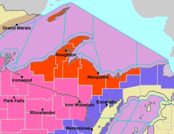
Including the cities of Grand Marais and Munising
…BLIZZARD WARNING IN EFFECT UNTIL 1 AM EST THURSDAY…
Heavy snow and blizzard conditions expected. Additional snow accumulations between 6 and 13 inches, highest near the Marquette/Alger county line. Winds gusting as high as 50 mph.
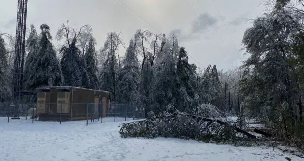
Travel could be very difficult to impossible. Widespread blowing snow could significantly reduce visibility. The hazardous conditions could impact the morning and evening commutes. Gusty winds could bring down tree branches. The strong winds and weight of snow on tree limbs may down power lines and could cause sporadic power outages.
Travel should be restricted to emergencies only. If you must travel, have a winter survival kit with you. If you get stranded, stay with your vehicle. If you must travel, keep an extra flashlight, food, and water in your vehicle in case of an emergency. Prepare for possible power outages.
Including the cities of Copper Harbor, Sidnaw, Houghton, Kenton, Ontonagon, and Hancock
…BLIZZARD WARNING IN EFFECT UNTIL 1 AM EST THURSDAY…
Blizzard conditions. Additional snow accumulations between 10 and 16 inches, greatest in the higher terrain of the Keweenaw Spine. Winds gusting as high as 50 mph.Travel could be very difficult to impossible. Widespread blowing snow could significantly reduce visibility. The hazardous conditions could impact the morning and evening commutes. Gusty winds could bring down tree branches.
Travel should be restricted to emergencies only. If you must travel, have a winter survival kit with you. If you get stranded, stay with your vehicle.
Including the cities of L`Anse, Gwinn, and Marquette
…BLIZZARD WARNING IN EFFECT UNTIL 1 AM EST THURSDAY…
Heavy snow expected and blizzard conditions expected. Additional snow accumulations between 8 and 12 inches along the Lake Superior shorelines, between 14 and 20 inches in the higher terrain of the Huron Mountains and the Michigamme Highlands, and between 4 and 8 inches in southern Marquette county. Winds gusting as high as 40 mph. Winds gusting as high as 40 mph with gusts to 50 mph near the Lake Superior shoreline. Travel could be very difficult to impossible. Widespread blowing snow could significantly reduce visibility.\
The hazardous conditions could impact the morning and evening commutes. Gusty winds could bring down tree branches. The strong winds and weight of snow on tree limbs may down power lines and could cause sporadic power outages.
Travel should be restricted to emergencies only. If you must travel, have a winter survival kit with you. If you get stranded, stay with your vehicle. If you must travel, keep an extra flashlight, food, and water in your vehicle in case of an emergency. Prepare for possible power outages.
Including the cities of Gladstone, Menominee, and Escanaba
…WINTER WEATHER ADVISORY REMAINS IN EFFECT UNTIL MIDNIGHT CST /1AM EST/ TONIGHT…
Mixed precipitation. Additional snow accumulations between 3 and 5 inches. Winds gusting as high as 40 mph. Plan on slippery road conditions. Areas of blowing snow could significantly reduce visibility. The hazardous conditions could impact the morning and evening commutes. Gusty winds could bring down tree branches. Slow down and use caution while traveling.
Including the cities of Seney and Newberry
…WINTER WEATHER ADVISORY REMAINS IN EFFECT UNTIL 1 AM EST THURSDAY…
Mixed precipitation expected. Total snow accumulations between 2 and 4 inches. Winds gusting as high as 40 mph. Plan on slippery road conditions. Areas of blowing snow could significantly reduce visibility. The hazardous conditions could impact the morning and evening commutes. Slow down and use caution while traveling.


Comments