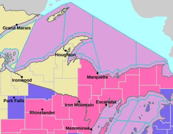
Including the cities of Munising, Gwinn, Grand Marais, and Marquette
…WINTER STORM WARNING NOW IN EFFECT FROM 3 PM THIS AFTERNOON TO 5 AM EDT THURSDAY…
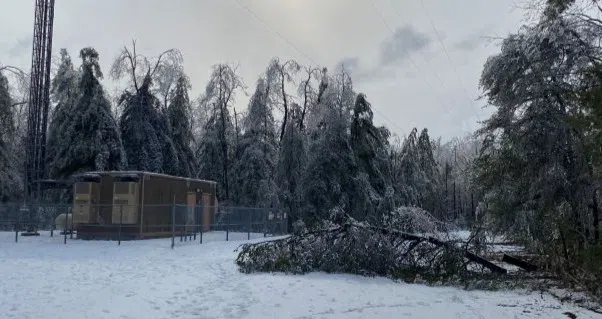
Heavy snow expected. Snow accumulations of 3 inches or less north of a line from Marquette to Republic. Snow accumulations of 3 to 7 inches expected elsewhere. Winds gusting as high as 40 mph Whiteout conditions are possible this evening and could make travel treacherous and potentially life-threatening. Travel could be very difficult. Widespread blowing snow could significantly reduce visibility. The hazardous conditions could impact the Wednesday evening commute. If you must travel, keep an extra flashlight, food, and water in your vehicle in case of an emergency. Prepare for possible power outages.
Including the cities of Manistique, Menominee, Gladstone, Seney, Newberry, and Escanaba
…WINTER STORM WARNING NOW IN EFFECT FROM 3 PM EDT /2 PM CDT/ THIS AFTERNOON TO 5 AM EDT /4 AM CDT/ THURSDAY…
Heavy snow expected. Total snow accumulations between 4 and 6 inches. Winds gusting as high as 40 mph across Delta, Luce, Menominee, and Schoolcraft Counties. Travel could be very difficult. Widespread blowing snow could significantly reduce visibility. The hazardous conditions could impact the Wednesday evening commute. If you must travel, keep an extra flashlight, food, and water in your vehicle in case of an emergency. Prepare for possible power outages.
Including the city of Iron Mountain
…WINTER STORM WARNING NOW IN EFFECT FROM 2 PM THIS AFTERNOON TO 1 AM CDT THURSDAY…
Heavy snow expected. Total snow accumulations between 2 and 7 inches, with the greatest amounts east of a line from Iron Mountain to K.I. Sawyer. Winds gusting as high as 35 mph. Travel could be very difficult. Widespread blowing snow could significantly reduce visibility. The hazardous conditions culd impact the Wednesday evening commute. If you must travel, keep an extra flashlight, food, and water in your vehicle in case of an emergency. Prepare for possible power outages.


Comments