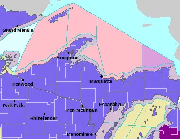
Including the cities of Ontonagon, Ironwood, Iron River, Iron Mountain, Kenton, and Sidnaw
…WINTER WEATHER ADVISORY REMAINS IN EFFECT FROM 8 PM EDT /7 PM CDT/ THIS EVENING TO 2 PM EDT /1 PM CDT/ WEDNESDAY…
…WINTER STORM WATCH IN EFFECT FROM WEDNESDAY EVENING THROUGH THURSDAY AFTERNOON…
For the Winter Weather Advisory, mixed precipitation of snow, sleet and freezing rain expected tonight and Wednesday morning. Total snow accumulations of up to one inch and ice accumulations of one tenth to two tenths of an inch. For the Winter Storm Watch, heavy snow possible Wednesday night and Thursday morning. Total snow accumulations of up to 6 inches and ice accumulations of a light glaze possible. Winds could gust as high as 35 mph.
Including the city of Menominee
WINTER WEATHER ADVISORY REMAINS IN EFFECT FROM 7 PM THIS EVENING TO 1 PM CDT WEDNESDAY…
Mixed precipitation expected. Total snow accumulations of up to one inch and ice accumulations of one tenth to two tenths of an inch tonight into Wednesday morning. Plan on slippery road conditions. The hazardous conditions could impact the Wednesday morning commute. The main part of the storm will be the mixed precipitation tonight into Wednesday morning. Light snow will occur for Wednesday night into Thursday.
Including the cities of Copper Harbor, Houghton, Hancock, L`Anse, Gwinn, and Marquette
WINTER WEATHER ADVISORY REMAINS IN EFFECT FROM 11 PM THIS EVENING TO 2 PM EDT WEDNESDAY…
WINTER STORM WATCH IN EFFECT FROM WEDNESDAY EVENING THROUGH THURSDAY AFTERNOON…
For the Winter Weather Advisory, mixed precipitation expected. Total snow accumulations of 1 to 3 inches and ice accumulations of up to two tenths of an inch tonight through Wednesday. For the Winter Storm Watch, heavy mixed precipitation possible. Total snow accumulations of up to 10 inches and ice accumulations of around one tenth of an inch possible Wednesday night and Thursday. Winds could gust as high as 40 mph.
Power outages and tree damage are likely due to the ice. Travel could be very difficult. Patchy blowing snow could significantly reduce visibility. The hazardous conditions could impact the morning and evening commutes through Thursday. This system will come in two parts. The first part will be the mixed precipitation for later tonight into Wednesday morning. The second part will be heavy snow Wednesday night into Thursday afternoon. Any changes in the track of the storm could result in changes to the ice and snow accumulations.
Including the cities of Escanaba and Gladstone
WINTER WEATHER ADVISORY REMAINS IN EFFECT FROM 11 PM THIS EVENING TO 2 PM EDT WEDNESDAY…
Mixed precipitation expected. Total snow accumulations of up to one inch and ice accumulations of one tenth to two tenths of an inch tonight into Wednesday morning. Plan on slippery road conditions. The hazardous conditions could impact the Wednesday morning commute. The main part of the storm will be the mixed precipitation tonight into Wednesday morning. Light snow will occur for Wednesday night into Thursday.
Including the cities of Grand Marais and Munising
WINTER WEATHER ADVISORY REMAINS IN EFFECT FROM 2 AM TO 2 PM EDT WEDNESDAY…
WINTER STORM WATCH IN EFFECT FROM WEDNESDAY EVENING THROUGH THURSDAY AFTERNOON…
For the Winter Weather Advisory, mixed precipitation expected. Total snow accumulations of up to one inch and ice accumulations of up to one tenth of an inch for tonight. For the Winter Storm Watch, heavy mixed precipitation possible Wednesday night with all snow for Thursday. Total snow accumulations of 3 to 5 inches and ice accumulations of up to two tenths of an inch possible. Winds could gust as high as 40 mph.
Power outages and tree damage are likely due to the ice. Travel could be very difficult. Patchy blowing snow could significantly reduce visibility. The hazardous conditions could impact the morning or evening commute.
This system will come in two parts. The first part will be the mixed precipitation for later tonight into Wednesday morning. The second part will be heavy snow Wednesday night into Thursday afternoon. Any changes in the track of the storm could result in changes to the ice and snow accumulations.
Including the cities of Newberry, Manistique, and Seney
WINTER WEATHER ADVISORY REMAINS IN EFFECT FROM 2 AM TO 2 PM EDT WEDNESDAY…
Mixed precipitation expected. Total snow accumulations of up to one inch and ice accumulations of up to one tenth of an inch late tonight into Wednesday morning. Winds gusting as high as 35 mph. Plan on slippery road conditions. The hazardous conditions could impact the Wednesday morning commute. The main part of the storm will be the mixed precipitation tonight into Wednesday morning. Light snow will occur for Wednesday night into Thursday.


")


Comments