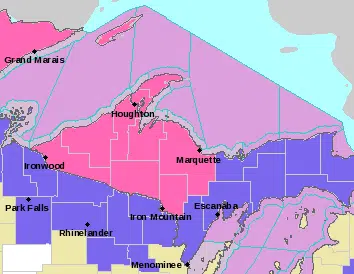
Including the cities of L`Anse, Gwinn, Marquette, Iron River, Iron Mountain, Kenton, and Sidnaw
…WINTER STORM WARNING IN EFFECT FROM 8 PM EDT /7 PM CDT/ THIS EVENING TO 8 PM EDT /7 PM CDT/ WEDNESDAY…
* WHAT…Heavy mixed precipitation expected. Total snow accumulations of 4 to 7 inches and ice accumulations of up to one quarter of an inch with locally higher amounts, especially in the higher terrain.
* WHERE…Baraga, Marquette, Iron, Dickinson and southern Houghton counties.
* WHEN…From 8 PM EDT /7 PM CDT/ this evening to 8 PM EDT /7 PM CDT/ Wednesday.
* IMPACTS…Travel could be very difficult. The hazardous conditions will impact the morning and eveningv commutes on Wednesday.
Including the cities of Grand Marais, Munising, Menominee, Escanaba, and Gladstone
…WINTER WEATHER ADVISORY REMAINS IN EFFECT FROM 8 PM EDT /7 PM CDT/ THIS EVENING TO 8 PM EDT /7 PM CDT/ WEDNESDAY…
* WHAT…Mixed precipitation expected. Total snow accumulations of 1 to 5 inches and ice accumulations of around one tenth of an inch. Winds gusting as high as 40 mph.
* WHERE…Alger, Delta, and Menominee counties.
* WHEN…From 8 PM EDT /7 PM CDT/ this evening to 8 PM EDT /7 PM CDT/ Wednesday.
* IMPACTS…Plan on slippery road conditions. The hazardous conditions could impact the morning and evening commutes on Wednesday.
Including the cities of Newberry, Manistique, and Seney
WINTER WEATHER ADVISORY NOW IN EFFECT FROM 2 AM TO 8 PM EDT WEDNESDAY…
* WHAT…Mixed precipitation expected. Total snow accumulations of 3 to 5 inches and ice accumulations of around one tenth of an inch. Winds gusting as high as 45 mph.
* WHERE…Luce and Schoolcraft counties.
* WHEN…From 2 AM to 8 PM EDT Wednesday.
* IMPACTS…Plan on slippery road conditions. The hazardous conditions could impact the morning and evening commutes on Wednesday.


")


Comments