Including the cities of Escanaba and Gladstone
…WINTER STORM WARNING REMAINS IN EFFECT FROM 3 PM THIS AFTERNOON TO 5 PM EDT MONDAY…
A wintry mix of snow, rain and freezing rain in heavy precipitation expected tonight. Ice accumulations of around a tenth of an inch are expected in the Rapid River, Perkins, Ensign and Nahma Junction areas.
Total snow accumulations of 2 to 10 inches…lowest along the bay of Green Bay shoreline and highest in the northern Delta County near Rock. Winds gusting as high as 40 mph. Power outages and tree damage are likely due to the ice. Travel could be nearly impossible. Patchy blowing snow could significantly reduce visibility.
The hazardous conditions could impact the Monday morning commute. The freezing rain and mixed precipitation would end by Monday morning and switch over to all snow. The strongest winds are expected Monday and could result in and sporadic power outages. If you must travel, keep an extra flashlight, food, and water in your vehicle in case of an emergency.
Including the cities of Newberry and Manistique
…WINTER WEATHER ADVISORY IN EFFECT FROM 6 AM TO 8 PM EDT MONDAY…
A mix of rain, snow, and freezing rain changing to snow Monday morning. Total snow accumulations of 2 to 4 inches and ice accumulations of a light glaze. Winds gusting as high as 45 mph. Travel could be very difficult. The hazardous
conditions could impact the Monday morning and evening commutes. The strongest winds are expected Monday
and could result in and sporadic power outages. Slow down and use caution while traveling.
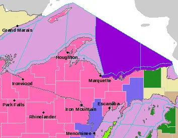
Including the cities of L`Anse, Gwinn, and Marquette
…WINTER STORM WARNING REMAINS IN EFFECT FROM 5 PM THIS AFTERNOON TO 8 AM EDT TUESDAY…
Heavy snow expected. Total snow accumulations of 10 to 24 inches and ice accumulations of a light glaze. The lightest snow totals will be in far southern Marquette County south of McFarland and in the Northland, Arnold, and Watson areas. The heaviest snow totals will be in the higher terrain west of Marquette. Winds gusting as high as 45 mph.
Travel could be very difficult to impossible. Areas of blowing snow could significantly reduce visibility with local whiteout conditions. The hazardous conditions could impact the Monday morning and evening commutes. The strongest winds are expected Monday and could result in tree damage and sporadic power outages. If you must travel, keep an extra flashlight, food, and water in your vehicle in case of an emergency.
Including the cities of Grand Marais and Munising
…WINTER STORM WARNING REMAINS IN EFFECT FROM 5 PM THIS AFTERNOON TO 8 AM EDT TUESDAY…
Heavy mixed precipitation expected. Total snow accumulations of 8 to 18 inches and ice accumulations of around one tenth of an inch. The lowest snow totals will be in the eastern half of Alger County near Grand Marais and the highest west of Munising. Winds gusting as high as 45 mph.
Travel could be very difficult. Areas of blowing snow could significantly reduce visibility with local whiteout conditions. The hazardous conditions could impact the Monday morning and evening commutes. Gusty winds could bring down tree branches. The strongest winds are expected Monday and could result in tree damage and sporadic power outages.
If you must travel, keep an extra flashlight, food, and water in your vehicle in case of an emergency.
Including the cities of Iron River and Iron Mountain
…WINTER STORM WARNING REMAINS IN EFFECT UNTIL 4 PM CDT MONDAY…
Heavy snow expected. Total snow accumulations of 8 to 16 inches. The lowest snow totals will be east of Iron Mountain. Winds gusting as high as 40 mph. Travel could be very difficult. Patchy blowing snow could significantly reduce visibility. The hazardous conditions could impact the Monday morning and evening commute. The strongest winds are expected Monday and could result in sporadic power outages.
Including the cities of Copper Harbor, Ontonagon, Houghton, Hancock, Ironwood, Kenton, and Sidnaw
…WINTER STORM WARNING REMAINS IN EFFECT FROM 5 PM EDT /4 PM CDT/ THIS AFTERNOON TO 2 AM EDT /1 AM CDT/ TUESDAY…
Heavy snow expected. Total snow accumulations of 10 to 19 inches. Winds gusting as high as 45 mph. Travel could be very difficult to impossible. Areas of blowing snow could significantly reduce visibility with local whiteout conditions.
The hazardous conditions could impact the Monday morning and evening commutes. The strongest winds are expected Monday and could result in tree damage and sporadic power outages. If you must travel, keep an extra flashlight, food, and water in your vehicle in case of an emergency.
Including the city of Menominee
…WINTER WEATHER ADVISORY REMAINS IN EFFECT FROM 2 PM THIS AFTERNOON TO 4 PM CDT MONDAY…
Mixed precipitation expected. Total snow accumulations of 2 to 7 inches and ice accumulations of a light glaze. Highest snow totals will be across northern Menominee County. Winds gusting as high as 40 mph.
Travel could be very difficult. The hazardous conditions could impact the Monday morning and evening commutes. The strongest winds are expected Monday and could result in and sporadic power outages. Slow down and use caution while traveling.


")


Comments