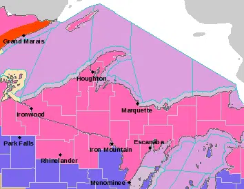
The National Weather Service has posted Winter Storm Warnings for the Upper Peninsula on Sunday, with some areas expecting to receive up to 18 inches of snow. It’s the first widespread weather event of the winter that is expected to impact all of the U.P. with snow and blowing snow. Dangerous travel conditions are expected, and power outages are possible with wind gusts of up to 30 miles per hour in the forecast.
The storm’s punch is expected to quickly wind down Sunday evening, but some parts of the Lake Superior snowbelt will see lake effect snow linger into Monday. Keep it tuned to the Radio Results Network, and radioresultsnetwork.com, for the latest weather announcements and updates.
Escanaba, Gladstone, Manistique, and Seney
425 AM EST Sun Dec 5 2021

...WINTER STORM WARNING REMAINS IN EFFECT FROM 7 AM THIS MORNING
TO 1 AM EST MONDAY...

* WHAT...Heavy snow expected. Total snow accumulations of 5 to 8
  inches.

* WHERE...Alger, Luce, Delta, Southern Schoolcraft and Northern
  Schoolcraft Counties.

* WHEN...From 7 AM this morning to 1 AM EST Monday.

* IMPACTS...Travel could become very difficult.

* ADDITIONAL DETAILS...Southeast winds gusting up to 30 mph this
  afternoon and early evening will cause some blowing and
  drifting snow.
Including the cities of Copper Harbor, Houghton, and Hancock
425 AM EST Sun Dec 5 2021

...WINTER STORM WARNING NOW IN EFFECT FROM 7 AM THIS MORNING TO
7 PM EST MONDAY...

* WHAT...Heavy snow expected. Total snow accumulations of 9 to 16
  inches. Southeast winds gusting up to 35 mph this afternoon,
  and north to northwest winds gusting to 35 to 45 mph late
  tonight and Monday morning.

* WHERE...Northern Houghton and Keweenaw Counties.

* WHEN...From 7 AM this morning to 7 PM EST Monday.

* IMPACTS...Travel could become very difficult to impossible.
  Blowing snow will significantly reduce visibility, especially
  late tonight and Monday morning. The hazardous conditions will
  impact the Monday morning commute.

* ADDITIONAL DETAILS...The moderate to heavy snow will transition
  to lake effect snow showers Monday afternoon.
Including the cities of Ontonagon and Ironwood
425 AM EST Sun Dec 5 2021 /325 AM CST Sun Dec 5 2021/

...WINTER STORM WARNING NOW IN EFFECT UNTIL 7 PM EST /6 PM CST/
MONDAY...

* WHAT...Heavy snow expected. Total snow accumulations of 10 to 18
  inches. The heaviest snow will occur late tonight and Monday
  morning. Southeast winds gusting up to 30 mph today, then
  northwest winds gusting to 30 to 40 mph late tonight and Monday
  morning.

* WHERE...Ontonagon and Gogebic Counties.

* WHEN...Until 7 PM EST /6 PM CST/ Monday.

* IMPACTS...Travel could become very difficult to impossible,
  especially late tonight and Monday morning. Patchy blowing snow
  could significantly reduce visibility. The hazardous conditions
  will impact the Monday morning commute.

* ADDITIONAL DETAILS...Moderate to occasional heavy snow today
  will diminish to light snow this evening. Heavy lake enhanced
  snow will then develop after midnight tonight, continuing into
  Monday morning, before a transition to lake effect snow showers
  Monday afternoon.
Including the cities of Gwinn, Marquette, Iron River,
and Iron Mountain
425 AM EST Sun Dec 5 2021 /325 AM CST Sun Dec 5 2021/

...WINTER STORM WARNING REMAINS IN EFFECT UNTIL 7 PM EST /6 PM
CST/ THIS EVENING...

* WHAT...Heavy snow expected. Total snow accumulations of 5 to 8
  inches.

* WHERE...Marquette, Dickinson and Iron Counties.

* WHEN...Until 7 PM EST /6 PM CST/ this evening.

* IMPACTS...Travel could become very difficult.

* ADDITIONAL DETAILS...Southeast winds gusting up to 30 mph this
  afternoon will cause some blowing and drifting snow.
Including the cities of L`Anse, Kenton, and Sidnaw
425 AM EST Sun Dec 5 2021

...WINTER STORM WARNING REMAINS IN EFFECT UNTIL 7 PM EST THIS
EVENING...

* WHAT...Heavy snow expected. Total snow accumulations of 4 to 7
  inches. The lowest snow accumulations will occur around Baraga
  and L`anse.

* WHERE...Baraga and Southern Houghton Counties.

* WHEN...Until 7 PM EST this evening.

* IMPACTS...Travel could become difficult.

* ADDITIONAL DETAILS...Southeast winds gusting up to 30 mph this
  afternoon will cause some blowing and drifting snow.

PRECAUTIONARY/PREPAREDNESS ACTIONS...

If you must travel, keep an extra flashlight, food, and water in
your vehicle in case of an emergency.
Including the city of Menominee
325 AM CST Sun Dec 5 2021

...WINTER STORM WARNING IN EFFECT UNTIL 6 PM CST THIS EVENING...

* WHAT...Heavy snow expected. Total snow accumulations of 6 to 9
  inches.

* WHERE...Menominee County.

* WHEN...Until 6 PM CST this evening.

* IMPACTS...Travel could become very difficult.

* ADDITIONAL DETAILS...Southeast winds gusting up to 30 mph this
  afternoon will cause some blowing and drifting snow.


")


Comments